Development Resources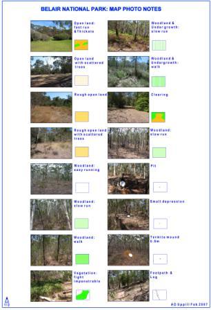
Note: This page is best viewed with a screen resolution of 1024 x 768 or greater.
Coaching Tips
- Map Photo Notes (thanks to Adrian Uppill, right)
- How to Orienteer
- Safe sport with Smartplay
How to Orienteer
The following resources are designed to assist newcomers and new members understand the map, an essential component to orienteering. States, clubs and members are encouraged to use these pages to assist in new particpants learning and enjoyment of the sport.
*Please note*: This material has been written and compiled by David Colls (ex-Australain Junior team member) and has been generously made available to Orienteering Australia. It is ONLY to be used or distributed by Orienteering Australia members for the purpose of assisting novice orienteers and new members. Educational, government and corporate institutions should consult with Orienteering Australia for terms of use. Use of this material for any other purpose should only be undertaken after consulting the author and purchasing the material through Orienteering Australia
Contents
- About the Coaching Tips
Orienteering map training - About
- Contents Page
Orienteering map training - Contents
- How to use Guide
Orienteering map training - How to Use Guide
- Contours
An Introduction to Contours.
Orienteering map training - Introduction to Contours
- Orientating the Map
Using the compass to align the map with the ground.
Orienteering map training - Using the Compass
- Man-Made Linear Features
Recognising roads, paths, fences, and similar features.
Orienteering map training - Man-made Features A
- Introduction to Vegetation
Interpreting vegetation of different thicknesses.
Orienteering map training - Vegetation A
- Naming Contour Features
Putting names to landforms depicted with contours.
Orienteering map training - Naming Contours
- Water Features
Recognising streams, marshes and similar features.
Orienteering map training - Water Features 
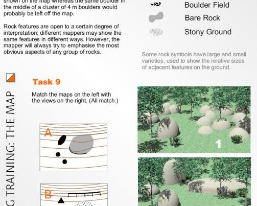
- Rock On!
Identifying rock features such as boulders and cliffs.
Orienteering map training - Rock
- Earthworks
Interpreting excavated features such as ditches.
Orienteering map training - Earth Features
- More Man-Made Features
Recognising features such as buildings and structures.
Orienteering map training - Man-made Features B
- Variations on Vegetation
Understanding variants of vegetation symbols.
Orienteering map training - Vegetation B
- Contours #2
Interpreting contours at an advanced level.
Orienteering map training - Advanced Contours
- On Course
Following the course on the map.
Orienteering map training - Following the Course on the Map
Safe Sport with Smartplay
Smartplay is.